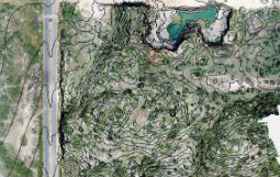
loader

Welcome to Deccan Survey SolutionsComplete Survey Solutions

Our Clients

About Us

Motto: "We take pride in everything we do"

Deccan Survey Solutions is a firm of registered land surveyors , engineers, and environmental consultants providing nation-wide coverage for projects of all sizes. We specialize in pipelines, gas and oil well locations, unit surveys, construction layouts, topographical boundaries, subdivision design, title and boundary surveys, geodetic control surveys, digitizing, map reproduction and preparation, wetlands delineation etc..

Our staff has many years of experience in the land surveying field, and is dedicated to providing our clients with quality surveys and survey services. In addition to our own extensive records.

Deccan Survey Solutions

Our Survey Services

See What We Do

Topographic Survey


Topographic Surveys for are used to identify and map the contours of the ground and existing features on the surface of the earth or slightly above or below the earths surface. in Interiors

Details

Contour Survey


We have been widely appreciated for offering excellent solution in form of Contour Survey. The Contour survey is carried out as per the international quality standards .

Details

Land Survey

We are Professionals in Land Surveys And in land survey field crews have year's of experience with field surveying and mapping on all property types in support of construction and development.

Details

Pipe Line Surveys

We are capable of handling all phases of a pipeline project, including preliminary route staking, preliminary route selection easement plats and descriptions, permit drawings etc..,

Details

Railway Survey


We have experience of carrying out railway surveys.We can work on network rail infrastructure.Railway surveying is focused on providing and managing the spatial information.

Details

Stakeout Survey


Stakeout Surveying is done in order to establish location of structures, objects and/or property corners based on proposed plans. Property corners are being staked out to define the limits of a site.

Details

Roads & Bridges Survey

We are Professionals in Land Surveys And in land survey field crews have year's of experience with field surveying and mapping on all property types in support of construction and development.

Details

Canal Survey


We are engaged in offering a quality Canal Survey Service to our clients. Canal crossing surveys determine bathymetry of waterways being crossed to establish a suitable route and aid in pipeline design.Details

Finished Projects

Experienced Surveying Services

WE BRING YOU THE AMAZING SERVICES

Land Survey

Surveying or land surveying is the technique, profession, and science of determining the terrestrial or three-dimensional position of points and the distances and angles between them.

GPR Survey

Ground-penetrating radar (GPR) is a geophysical method that uses radar pulses to image the subsurface. This nondestructive method uses electromagnetic radiation in the microwave band (UHF/VHF frequencies).

Facade Survey

Facades and Elevations Surveying is a process of accurately measuring the elevations or sides of buildings to record all of the features such as windows, doors, parapets, roofs and columns.

Topographical Survey

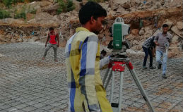
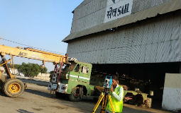
Topographic Surveys are used to identify and map the contours of the ground and existing features on the surface of the earth or slightly above or below the earths surface.

150

Loyal Clients

200

Projects Completed

65

Auctions Won

Happy Clients

JUST LISTEN TO WHAT OUR CLIENTS HAVE TO SAY

  • An extremely professional set up, a fantastic educator. Highly recommended. I'll be back!

    - Construction Company Hyderabad
  • The Company is informative, friendly and offers great advice to students. Everything was explained in detail, and you are made to feel like you are part of a family.

    - Engineering College Hyderabad
Working with us

Land Survey Contractors & Construction
Managers Since 2017

About Us

Our Clients